Vision for improved cycling networks in Battle and Rye


East Sussex County Council’s is consulting the public on its first local cycling and walking infrastructure plan (LCWIP).
The draft document splits the county up into six areas: Eastbourne and South Downs (including Hailsham and Polegate), Hastings and Bexhill, Newhaven area (including Peacehaven and Seaford), Lewes and South Downs, rural Rother and north Wealden & north Lewes (including Uckfield, Heathfield and Crowborough).
Advertisement
Hide AdAdvertisement
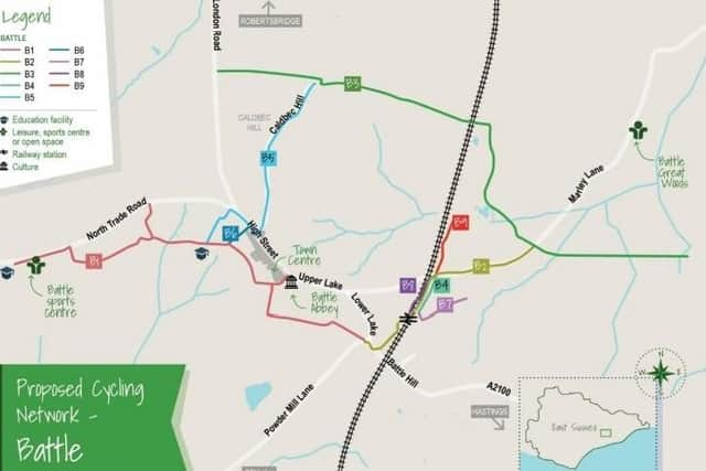
Hide AdProposed cycle network maps have been produced for each of the areas as well as walking network maps for Newhaven, Lewes, Eastbourne, Hailsham, Bexhill and Hastings.
Alongside this is a programme of cycling and walking infrastructure improvements.
These do not contain detailed proposals, but indicate potential alignments of routes or measures, with an emphasis on demonstrating how they can connect with places people may travel for everyday journeys.
The LCWIP ‘sets out an ambitious network of additional cycling and walking routes and measures integrated with existing cycling and walking infrastructure’.
Advertisement
Hide AdAdvertisement
Hide AdIt adds: “This is set alongside the wider transport network, with the aim to maximise the potential to support new housing and employment space coming forward. This first version of the LCWIP will be focussed on those areas where there are the greatest opportunities to increase levels of cycling and walking.”
Focusing on Battle and Rye, the plan says: “These historic smaller settlements are set within a more rural environment which is surrounded by Areas of Outstanding Natural Beauty. Alongside the large numbers of tourists which these towns attract they also provide a role as a service centre for nearby rural villages. Therefore, the routes are focussed on supporting local access both within and to the settlements.”
In Battle proposed routes are: B1/B2 Battle Schools Greenway, B3 Uckham Lane, Marley Lane, Great Wood, B4/B7/B8/B9 Links to Blackfriars redevelopment , B5 Battle North and B6 Link Automotive Estates.
Meanwhile the proposed cycle routes in Rye are: R1 Rye - Rye Harbour - Winchelsea Loop, R2 Valley Park - Rock Channel, R3 Valley Park - Camber - Jury’s Gap, R4 Peasmarsh - Military Road, R5 Playden Lane, R6 School Lane, R7 Peasmarsh - Landgate, R8 Rye Harbour Alternative, R9 Winchelsea Road - Harbour Road, R10 Camber Alternative, R11 Mason Road, R12 Ferry Road - Love Lane, R13 Cinque Ports Street - Winchelsea, R14 Rye - Playden, R15 Military Road, R16 Rye - Iden Lock, R17 New Road - Scots Float Sluice and R18 Rock Channel.
Advertisement
Hide AdAdvertisement
Hide AdThe delivery of the plan will rely on the county council and its partners securing external funding and buildings on £23million already secured since 2014 to deliver active travel measures through the local transport capital programme.
Claire Dowling, lead member for transport and environment, said: “Walking and cycling not only improves people’s health and wellbeing, it can help protect the environment and improve air quality.
“Some people have been able to re-think how they travel since the beginning of the Covid-19 pandemic with cycling and walking becoming more of an option. We are keen to put in place infrastructure to support the opportunity to change habits and enable others to find more active and healthy ways to travel.”
In line with guidance from the Department for Transport, the county’s first plan will focus on areas where there is the greatest opportunity to increase levels of cycling and walking and therefore, to attract external funding – this includes the coastal strip and larger market towns in the county.
Advertisement
Hide AdAdvertisement
Hide AdIn rural areas, the council will look at how walking and cycling can be supported through its local transport plan, as well as local and neighbourhood plans. Officers will continue to work with local partners to identify opportunities and funding for active travel.
Cllr Dowling added: “It’s vital that people take this opportunity to comment and help us create a plan that supports active travel and understands the needs of local communities.”
The consultation runs until Friday December 11 and all responses will be carefully considered before a final version of the plan is agreed.
To find out more about the plan and to take part in the consultation, visit https://consultation.eastsussex.gov.uk/economy-transport-environment/escc-lcwip-2020/